On-line soil sensing
An innovative on-line (tractor driven) visible and near infrared (vis-NIR) spectroscopy-based multi-sensor platform that collects geo-located soil measurements at high sampling resolution (>1500 sample per ha) is available at UGent. The sensor provides a wide range of valuable information for the farmer, based on a single data collection exercise. The soil parameters that can be measured with different degree of accuracy at any depth between 5-30 cm are bulk density indicating soil compaction, total nitrogen, organic carbon, moisture content, phosphorous, potassium, pH, calcium, magnesium, clay content and cation exchange capacity. This multi-layer of data when combined with advanced modelling tools and control technologies of farming input resources (e.g., fertilisers, water for irrigation, seeds) they would lead to successful site specific soil and crop management practices ((know also as variable rate applications) at the field scale for sustainable increase in farming production efficiency and reduction in environmental footprint.
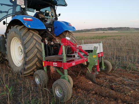
Among the proximal soil sensing technology the vis-NIR spectroscopy is proven to be the best technology to provide quantitative readings on key soil fertility parameters. Our internationally patent multi-sensor platform to measure key soil fertility parameters consists of a subsoiler fitted to a metal frame, which is attachable to the three-point hitch of a tractor. The subsoiler makes around 15 to 20 cm deep trenches in the topsoil, the bottom of which is smoothened by the subsoiler itself due to its downward forces. An optical probe hosted in a mild steel holder (appended at the backside of the subsoiler chisel) measures soil spectra in diffuse reflectance mode from the smoothed bottom of the trench. A fiber-type spectrophotometer (CompactSpec from Tec5 Technology, Germany), with a spectral range of 305 to 1700 nm and a sampling resolution of 1 nm is used to record soil spectra. A 100 % ceramic disk of 50 mm in diameter is used as the white reference to recalibrate the sensor once in every 30 minutes of the field scanning. A differential global positioning system (Trimble AG., Trimble Navigation Ltd., Sunnyvale, Canada) recorded the corresponding latitudes and longitudes during on-line soil scanning and sampling. Geo-referenced soil spectral data are logged at a frequency of 1 Hz through a standard data logging software package, MultiSpec pro-II (Tec5 Technology, Germany) installed on a semi-rugged laptop computer (Toughbook, Panasonic UK Ltd., Bracknell, UK). The sensing platform is driven at 3.5 km/hr forward speed along the parallel sensing transects at 12 m intervals.
Traditionally, inherited spatial and temporal variation of soil properties and nutrients are characterized by a limited number of samples ((typically 1 soil samples per 1-3 hectare) being pooled into one "representative" sample, on which a number of soil properties are analysed in the laboratory. A similar single-value approach is followed to characterise other growing conditions and to determine crop characteristics and yield. Increasing the number of samples and analyse them individually to characterise the within-field variability is prohibited by the extra effort and costs involved. To overcome the bottleneck of data acquisition by traditional means, soil inventory has evolved into the direction of proximal soil sensing. This is according to the paradigm "Measure more, less precise". Or in other words, bring the laboratory measurements into the field to increase the spatial coverage, but at the cost of measurement precision.
Although digital agricultural tools exist commercially, the majority of farmers apply different forms of farming inputs homogeneously over entire field area, resulting in over- and under-applications over different parts of the field. Zones receiving over-application, input will not be consumed by the crop but wasted, and in the case of fertilizers extra nutrients will leach into the ground and surface waters, increasing their concentrations and the consequent environmental issues. In other zones, the crop might receive smaller rates than necessary for their growth, hence, crop performance will be deteriorated, leading to less yield than possible, causing economic losses. Therefore, it is necessary to manage within field soil variability. This can be achieved by variable rate applications (VRA), using advanced sensing, modelling and control technology, where the on-line multi-sensor platform of UGent has been proven to provide necessary data for optimal VRA, that recorded increases in yield and profitability, and reduction in environmental footprint.
We are open to mobilize the multi-sensor platform among different EU countries and beyond. The sensor has been used already for measurements in the UK, Belgium, the Netherlands, Germany, Turkey, Spain, Portugal, Denmark and Czech Republic, with planned measurement in Lithuania this summer.